Waza National Park: A Glimpse into Cameroon’s Rich Ecosystem
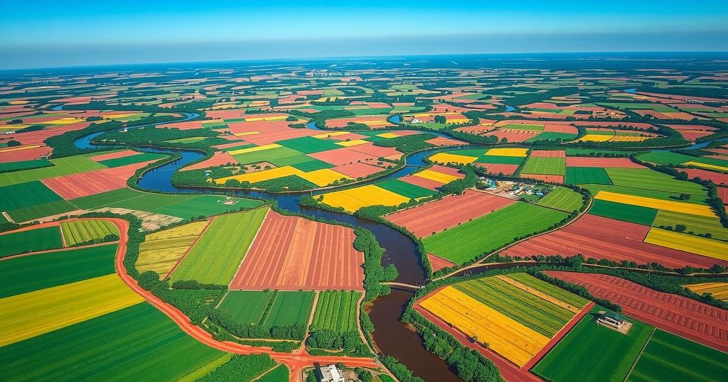
The Copernicus Sentinel-2 mission showcases Waza National Park in northern Cameroon, highlighting its ecological significance as a UNESCO World Heritage site. The park spans 1,700 square kilometers and is renowned for its diverse wildlife. Surrounding the park is the Logone floodplain, affected by the seasonal flooding of the Logone River, supporting local agriculture and fishing for over 100,000 residents.
The Copernicus Sentinel-2 mission has beautifully captured the landscape surrounding Waza National Park in Cameroon. This national park, located in the northernmost region of Cameroon, spans approximately 1,700 square kilometers and lies close to the borders of Chad to the east and Nigeria to the west.
Waza National Park, visible in the lower left of the image, is recognized as Cameroon’s most diverse wildlife reserve, hosting a variety of species such as lions, elephants, giraffes, antelopes, and many bird species. In 1979, it was designated a UNESCO World Heritage biosphere reserve due to its ecological significance.
The adjacent town of Waza appears as a small yellowish region bordered by verdant land. The encompassing green area represents the Logone floodplain, part of the Lake Chad basin, enriched by seasonal inundation from the Logone River, which can be seen as a brown ribbon flowing eastward along the Cameroon-Chad border.
This region’s ecosystem is influenced by alternating wet and dry seasons. From mid-May to mid-October, the area experiences flooding, transforming into a rich temporary wetland that supports various flora like grasses and reeds, alongside seasonal water bodies.
Over 100,000 people reside in this vicinity, relying on the seasonal floods for fishing, grazing, and agricultural activities. Agricultural patches can be noted in the image, especially the prominent field situated to the left of the Logone River.
The image was recorded in November 2024, a time when floodwaters are typically receding, leaving the surroundings vibrant and fertile. Indications of the upcoming dry season are apparent, as the park maintains its natural vegetation while surrounding lands transition to post-harvest stubble or fallow fields, marked by brown shades.
In addition, the Chari River, the main tributary of Lake Chad, appears green on the right side of the image. The Chari River flows northward, merging with the Logone River before eventually reaching Lake Chad, which is not depicted in this image. N’Djamena, the capital city of Chad, is situated at the confluence of both rivers and is identifiable as a large gray area at the top of the image.
In conclusion, the Waza National Park showcases a unique ecosystem shaped by seasonal flood cycles, supporting diverse wildlife and local communities. This remarkable region illustrates the interconnection between natural landscapes and human livelihoods. The imagery from the Copernicus Sentinel-2 mission highlights the ecological significance of the area, particularly as it transitions between wet and dry seasons, thereby underscoring the importance of preserving such vital habitats.
Original Source: www.esa.int


Post Comment